AIM
4/3/14
7−1−44
Meteorology
TBL 7
−1−7
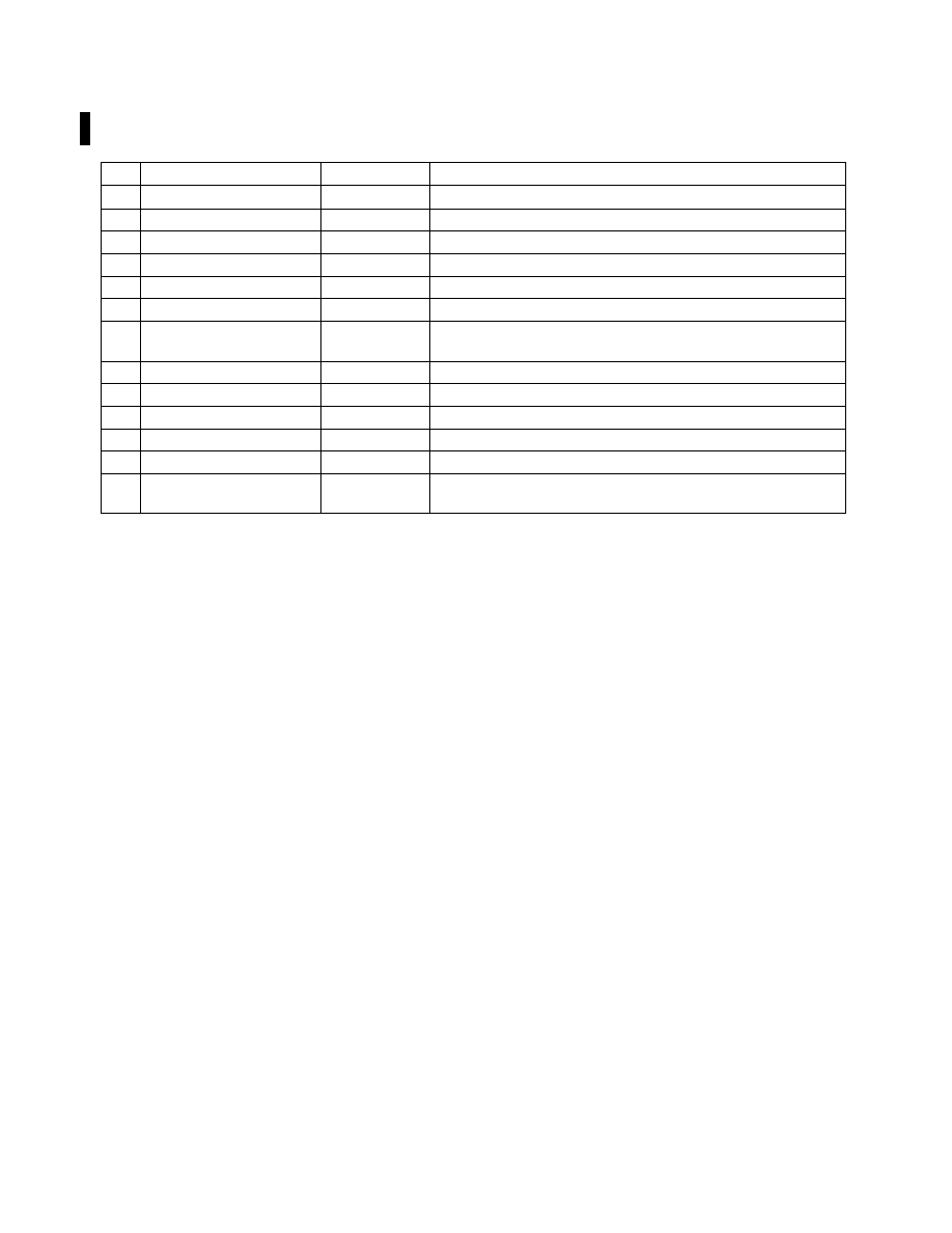
PIREP Element Code Chart
PIREP ELEMENT
PIREP CODE
CONTENTS
1.
3−letter station identifier
XXX
Nearest weather reporting location to the reported phenomenon
2.
Report type
UA or UUA
Routine or Urgent PIREP
3.
Location
/OV
In relation to a VOR
4.
Time
/TM
Coordinated Universal Time
5.
Altitude
/FL
Essential for turbulence and icing reports
6.
Type Aircraft
/TP
Essential for turbulence and icing reports
7.
Sky cover
/SK
Cloud height and coverage (sky clear, few, scattered, broken, or
overcast)
8.
Weather
/WX
Flight visibility, precipitation, restrictions to visibility, etc.
9.
Temperature
/TA
Degrees Celsius
10. Wind
/WV
Direction in degrees magnetic north and speed in knots
11. Turbulence
/TB
12. Icing
/IC
See AIM paragraph NO TAG
13. Remarks
/RM
For reporting elements not included or to clarify previously
reported items
EXAMPLE
−
1. KCMH UA /OV APE 230010/TM 1516/FL085/TP
BE20/SK BKN065/WX FV03SM HZ FU/TA 20/TB LGT
NOTE
−
1. One zero miles southwest of Appleton VOR; time
1516 UTC; altitude eight thousand five hundred; aircraft
type BE200; bases of the broken cloud layer is six thousand
five hundred; flight visibility 3 miles with haze and smoke;
air temperature 20 degrees Celsius; light turbulence.
EXAMPLE
−
2. KCRW UV /OV KBKW 360015
−KCRW/TM
1815/FL120//TP BE99/SK IMC/WX RA/TA M08 /WV
290030/TB LGT
−MDT/IC LGT RIME/RM MDT MXD
ICG DURC KROA NWBND FL080
−100 1750Z
NOTE
−
2. From 15 miles north of Beckley VOR to Charles-
ton VOR; time 1815 UTC; altitude 12,000 feet; type
aircraft, BE
−99; in clouds; rain; temperature minus
8 Celsius; wind 290 degrees magnetic at 30 knots; light to
moderate turbulence; light rime icing during climb
northwestbound from Roanoke, VA, between 8,000 and
10,000 feet at 1750 UTC.
7
−
1
−
21. PIREPs Relating to Airframe Icing
a.
The effects of ice on aircraft are cumulative-
thrust is reduced, drag increases, lift lessens, and
weight increases. The results are an increase in stall
speed and a deterioration of aircraft performance. In
extreme cases, 2 to 3 inches of ice can form on the
leading edge of the airfoil in less than 5 minutes. It
takes but
1
/
2
inch of ice to reduce the lifting power of
some aircraft by 50 percent and increases the
frictional drag by an equal percentage.
b.
A pilot can expect icing when flying in visible
precipitation, such as rain or cloud droplets, and the
temperature is between +02 and −10 degrees Celsius.
When icing is detected, a pilot should do one of two
things, particularly if the aircraft is not equipped with
deicing equipment; get out of the area of
precipitation; or go to an altitude where the
temperature is above freezing. This “warmer”
altitude may not always be a lower altitude. Proper
preflight action includes obtaining information on the
freezing level and the above freezing levels in
precipitation areas. Report icing to ATC, and if
operating IFR, request new routing or altitude if icing
will be a hazard. Be sure to give the type of aircraft to
ATC when reporting icing. The following describes
how to report icing conditions.
1. Trace.
Ice becomes perceptible. Rate of
accumulation slightly greater than sublimation.
Deicing/anti-icing equipment is not utilized unless
encountered for an extended period of time (over
1 hour).