AIM
8/15/19
3
−
5
−
9
Other Airspace Areas
3
−
5
−
6. Terminal Radar Service Area (TRSA)
a. Background.
TRSAs were originally estab-
lished as part of the Terminal Radar Program at
selected airports. TRSAs were never controlled
airspace from a regulatory standpoint because the
establishment of TRSAs was never subject to the
rulemaking process; consequently, TRSAs are not
contained in 14 CFR Part 71 nor are there any TRSA
operating rules in 14 CFR Part 91. Part of the Airport
Radar Service Area (ARSA) program was to
eventually replace all TRSAs. However, the ARSA
requirements became relatively stringent and it was
subsequently decided that TRSAs would have to
meet ARSA criteria before they would be converted.
TRSAs do not fit into any of the U.S. airspace classes;
therefore, they will continue to be non
−
Part 71
airspace areas where participating pilots can receive
additional radar services which have been redefined
as TRSA Service.
b. TRSAs.
The primary airport(s) within the
TRSA become(s) Class D airspace. The remaining
portion of the TRSA overlies other controlled
airspace which is normally Class E airspace
beginning at 700 or 1,200 feet and established to
transition to/from the en route/terminal environment.
c. Participation.
Pilots operating under VFR are
encouraged to contact the radar approach control and
avail themselves of the TRSA Services. However,
participation is voluntary on the part of the pilot. See
Chapter 4, Air Traffic Control, for details and
procedures.
d. Charts.
TRSAs are depicted on VFR sectional
and terminal area charts with a solid black line and
altitudes for each segment. The Class D portion is
charted with a blue segmented line.
3
−
5
−
7. Special Air Traffic Rules (SATR) and
Special Flight Rules Area (SFRA)
a. Background.
The Code of Federal Regulations
(CFR) prescribes special air traffic rules for aircraft
operating within the boundaries of certain designated
airspace. These areas are listed in 14 CFR Part 93 and
can be found throughout the NAS. Procedures, nature
of operations, configuration, size, and density of
traffic vary among the identified areas.
b. SFRAs.
Airspace of defined dimensions, above
land areas or territorial waters, within which the flight
of aircraft is subject to the rules set forth in 14 CFR
Part 93, unless otherwise authorized by air traffic
control. Not all areas listed in 14 CFR Part 93 are
designated SFRA, but special air traffic rules apply to
all areas described in 14 CFR Part 93.
REFERENCE
−
14 CFR Part 93, Special Air Traffic Rules
FAA Order JO 7110.65, Para 9
−
2
−
10, Special Air Traffic Rules (SATR)
and Special Flight Rules Area (SFRA)
PCG
−
Special Air Traffic Rules (SATR)
c. Participation.
Each person operating an
aircraft to, from, or within airspace designated as a
SATR area or SFRA must adhere to the special air
traffic rules set forth in 14 CFR Part 93, as applicable,
unless otherwise authorized or required by ATC.
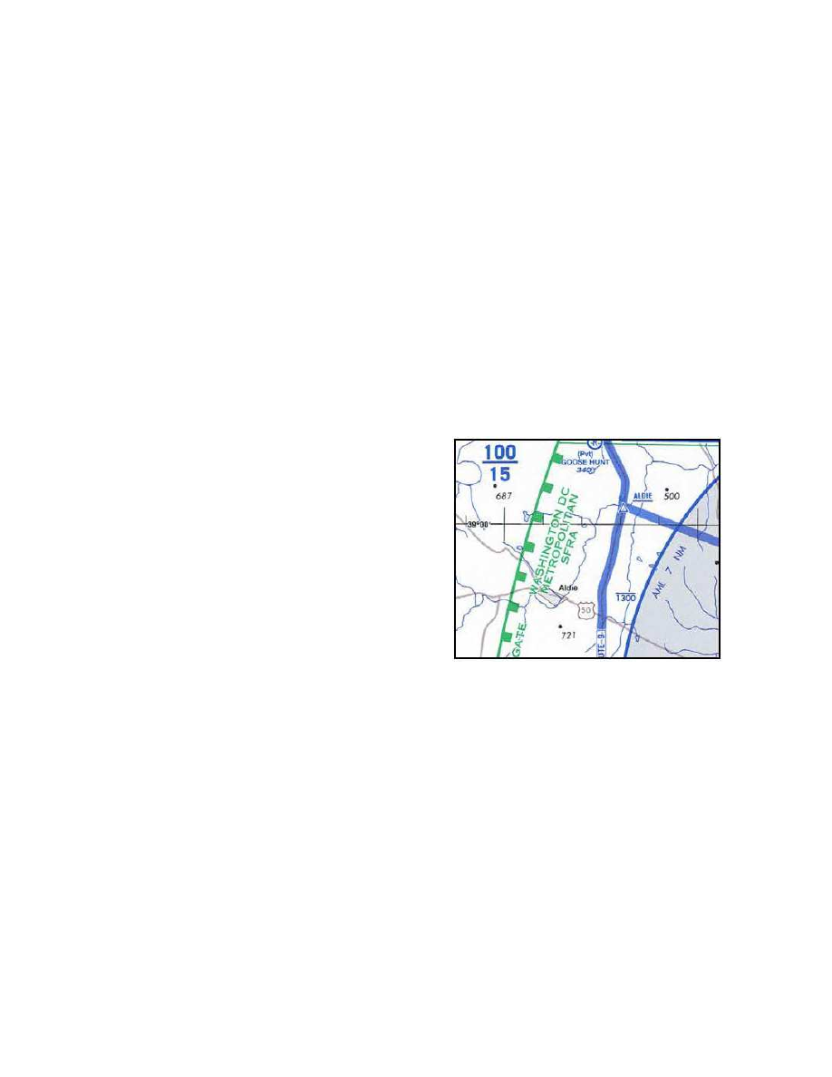
d. Charts.
SFRAs are depicted on VFR sectional,
terminal area, and helicopter route charts. (See
FIG 3
−
5
−
4.)
FIG 3
−
5
−
4
SFRA Boundary
e.
Additional information and resources regarding
SFRA, including procedures for flight in individual
areas, may be found on the FAA Safety website at
www.faasafety.gov.
3
−
5
−
8. Weather Reconnaissance Area
(WRA)
a. General.
Hurricane Hunters from the United
States Air Force Reserve 53
rd
Weather
Reconnaissance Squadron (WRS) and the National
Oceanic and Atmospheric Administration (NOAA)
Aircraft Operations Center (AOC) operate weather
reconnaissance/research aircraft missions, in support
of the National Hurricane Operations Plan (NHOP),
to gather meteorological data on hurricanes and
tropical cyclones. 53
rd
WRS and NOAA AOC
aircraft normally conduct these missions in airspace