AIM
8/15/19
4
−
1
−
10
Services Available to Pilots
position in terms of the eight cardinal compass points
(N, NE, E, SE, S, SW, W, NW). This method must be
terminated at the pilot’s request.
(c)
Distance from the aircraft in nautical
miles;
(d)
Direction in which the target is proceed-
ing; and
(e)
Type of aircraft and altitude if known.
EXAMPLE
−
Traffic 10 o’clock, 3 miles, west-bound (type aircraft and
altitude, if known, of the observed traffic). The altitude may
be known, by means of Mode C, but not verified with the
pilot for accuracy. (To be valid for separation purposes by
ATC, the accuracy of Mode C readouts must be verified.
This is usually accomplished upon initial entry into the
radar system by a comparison of the readout to pilot stated
altitude, or the field elevation in the case of continuous
readout being received from an aircraft on the airport.)
When necessary to issue traffic advisories containing
unverified altitude information, the controller will issue the
indicated altitude of the aircraft. The pilot may upon
receipt of traffic information, request a vector (heading) to
avoid such traffic. The vector will be provided to the extent
possible as determined by the controller provided the
aircraft to be vectored is within the airspace under the
jurisdiction of the controller.
2. Not radar identified
(a)
Distance and direction with respect to a
fix;
(b)
Direction in which the target is proceed-
ing; and
(c)
Type of aircraft and altitude if known.
EXAMPLE
−
Traffic 8 miles south of the airport northeastbound, (type
aircraft and altitude if known).
d.
The examples depicted in the following figures
point out the possible error in the position of this
traffic when it is necessary for a pilot to apply drift
correction to maintain this track. This error could also
occur in the event a change in course is made at the
time radar traffic information is issued.
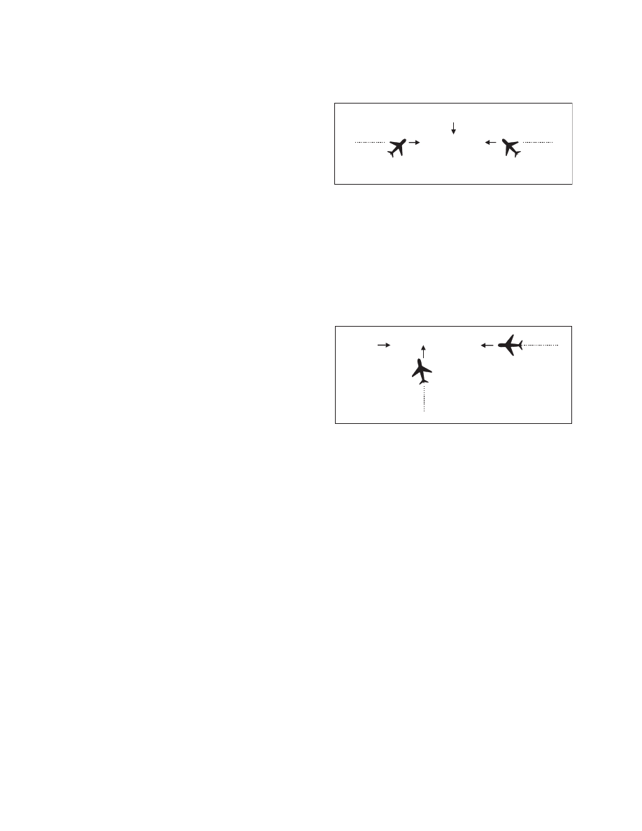
FIG 4
−
1
−
1
Induced Error in Position of Traffic
TRACK
(A)
(B)
WIND
TRACK
EXAMPLE
−
In FIG 4
−
1
−
1 traffic information would be issued to the
pilot of aircraft “A” as 12 o’clock. The actual position of
the traffic as seen by the pilot of aircraft “A” would be
2 o’clock. Traffic information issued to aircraft “B” would
also be given as 12 o’clock, but in this case, the pilot of “B”
would see the traffic at 10 o’clock.
FIG 4
−
1
−
2
Induced Error in Position of Traffic
TRACK
(C)
(D)
WIND
TRACK
EXAMPLE
−
In FIG 4
−
1
−
2 traffic information would be issued to the
pilot of aircraft “C” as 2 o’clock. The actual position of the
traffic as seen by the pilot of aircraft “C” would be
3 o’clock. Traffic information issued to aircraft “D” would
be at an 11 o’clock position. Since it is not necessary for the
pilot of aircraft “D” to apply wind correction (crab) to
remain on track, the actual position of the traffic issued
would be correct. Since the radar controller can only
observe aircraft track (course) on the radar display, traffic
advisories are issued accordingly, and pilots should give
due consideration to this fact when looking for reported
traffic.
4
−
1
−
16. Safety Alert
A safety alert will be issued to pilots of aircraft being
controlled by ATC if the controller is aware the
aircraft is at an altitude which, in the controller’s
judgment, places the aircraft in unsafe proximity to
terrain, obstructions or other aircraft. The provision
of this service is contingent upon the capability of the
controller to have an awareness of a situation
involving unsafe proximity to terrain, obstructions
and uncontrolled aircraft. The issuance of a safety
alert cannot be mandated, but it can be expected on a