AIM
8/15/19
7
−
1
−
42
Meteorology
northwestbound from Roanoke, VA, between 8,000 and
10,000 feet at 1750 UTC.
f.
For more detailed information on PIREPS, users
can refer to the current version of AC 00
−
45, Aviation
Weather Services.
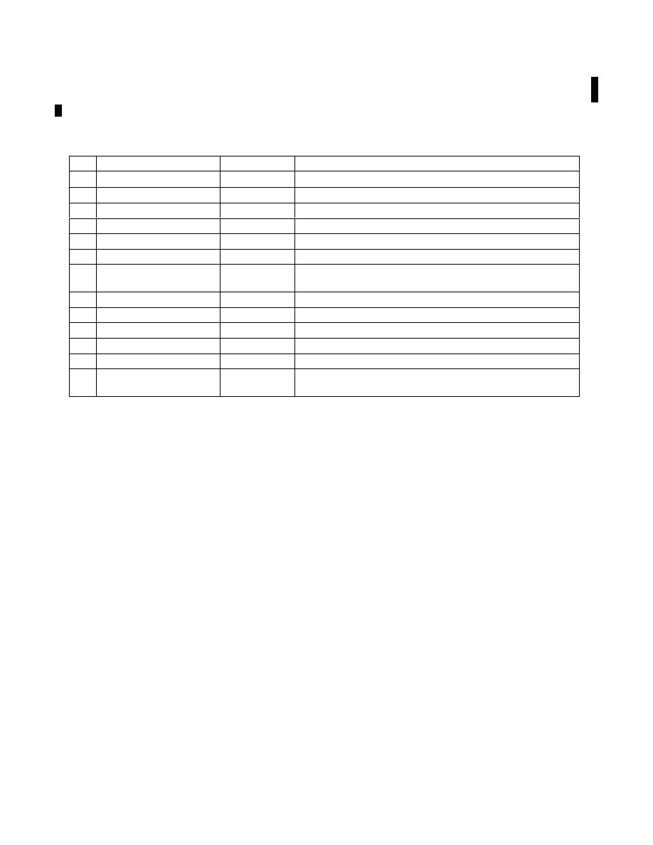
TBL 7
−
1
−
7
PIREP Element Code Chart
PIREP ELEMENT
PIREP CODE
CONTENTS
1.
3
−
letter station identifier
XXX
Nearest weather reporting location to the reported phenomenon
2.
Report type
UA or UUA
Routine or Urgent PIREP
3.
Location
/OV
In relation to a VOR
4.
Time
/TM
Coordinated Universal Time
5.
Altitude
/FL
Essential for turbulence and icing reports
6.
Type Aircraft
/TP
Essential for turbulence and icing reports
7.
Sky cover
/SK
Cloud height and coverage (sky clear, few, scattered, broken, or
overcast)
8.
Weather
/WX
Flight visibility, precipitation, restrictions to visibility, etc.
9.
Temperature
/TA
Degrees Celsius
10.
Wind
/WV
Direction in degrees magnetic north and speed in knots
11.
Turbulence
/TB
See AIM paragraph 7
−
1
−
23
12.
Icing
/IC
See AIM paragraph 7
−
1
−
21
13.
Remarks
/RM
For reporting elements not included or to clarify previously
reported items
7
−
1
−
21. PIREPs Relating to Airframe Icing
a.
The effects of ice on aircraft are cumulative-
thrust is reduced, drag increases, lift lessens, and
weight increases. The results are an increase in stall
speed and a deterioration of aircraft performance. In
extreme cases, 2 to 3 inches of ice can form on the
leading edge of the airfoil in less than 5 minutes. It
takes but
1
/
2
inch of ice to reduce the lifting power of
some aircraft by 50 percent and increases the
frictional drag by an equal percentage.
b.
A pilot can expect icing when flying in visible
precipitation, such as rain or cloud droplets, and the
temperature is between +02 and
−
10 degrees Celsius.
When icing is detected, a pilot should do one of two
things, particularly if the aircraft is not equipped with
deicing equipment; get out of the area of
precipitation; or go to an altitude where the
temperature is above freezing. This “warmer”
altitude may not always be a lower altitude. Proper
preflight action includes obtaining information on the
freezing level and the above freezing levels in
precipitation areas. Report icing to ATC, and if
operating IFR, request new routing or altitude if icing
will be a hazard. Be sure to give the type of aircraft to
ATC when reporting icing. The following describes
how to report icing conditions.
1. Trace.
Ice becomes perceptible. Rate of
accumulation slightly greater than sublimation.
Deicing/anti-icing equipment is not utilized unless
encountered for an extended period of time (over
1 hour).
2. Light.
The rate of accumulation may create
a problem if flight is prolonged in this environment
(over 1 hour). Occasional use of deicing/anti-icing
equipment removes/prevents accumulation. It does
not present a problem if the deicing/anti-icing
equipment is used.
3. Moderate.
The rate of accumulation is such
that even short encounters become potentially
hazardous and use of deicing/anti-icing equipment or
flight diversion is necessary.
4. Severe.
The rate of accumulation is such that
ice protection systems fail to remove the accumula-
tion of ice, or ice accumulates in locations not
normally prone to icing, such as areas aft of protected
surfaces and any other areas identified by the