Index
497
-- Page 498 --
499
7110.65R
AIM
AIM      CHG 2                                                                                             3/15/07
                                                                                                           5/26/16
                                                                                                          12/10/15


    6. The Terminal Weather Information for               within 30 NM surrounding the terminal area, and
Pilots System (TWIP).                                     expected weather that will impact airport operations.
                                                          During inclement weather, i.e., whenever a predeter-
       (a) With the increase in the quantity and
                                                          mined level of precipitation or wind shear is detected
quality of terminal weather information available
                                                          within 15 miles of the terminal area, TWIP products
through TDWR, the next step is to provide this
                                                          are updated once each minute for text messages and
information directly to pilots rather than relying on
                                                          once every five minutes for character graphic
voice communications from ATC. The National
                                                          messages. During good weather (below the predeter-
Airspace System has long been in need of a means of
                                                          mined precipitation or wind shear parameters) each
delivering terminal weather information to the
                                                          message is updated every 10 minutes. These products
cockpit more efficiently in terms of both speed and
                                                          are intended to improve the situational awareness of
accuracy to enhance pilot awareness of weather
                                                          the pilot/flight crew, and to aid in flight planning prior
hazards and reduce air traffic controller workload.
                                                          to arriving or departing the terminal area. It is
With the TWIP capability, terminal weather
                                                          important to understand that, in the context of TWIP,
information, both alphanumerically and graphically,
                                                          the predetermined levels for inclement versus good
is now available directly to the cockpit at 43 airports
                                                          weather has nothing to do with the criteria for
in the U.S. NAS. (See FIG 7-1-18.)
                                                          VFR/MVFR/IFR/LIFR; it only deals with precipita-

                      FIG 7-1-18                          tion, wind shears and microbursts.
         TWIP Image of Convective Weather                                          TBL 7-1-11
               at MCO International                                     TWIP-Equipped Airports
                                                          Airport                                       Identifier
                                                          Andrews AFB, MD                               KADW
                                                          Hartsfield-Jackson Atlanta Intl Airport       KATL
                                                          Nashville Intl Airport                        KBNA
                                                          Logan Intl Airport                            KBOS
                                                          Baltimore/Washington Intl Airport             KBWI
                                                          Hopkins Intl Airport                          KCLE
                                                          Charlotte/Douglas Intl Airport                KCLT
                                                          Port Columbus Intl Airport                    KCMH
                                                          Cincinnati/Northern Kentucky Intl Airport KCVG
       (b) TWIP products are generated using              Dallas Love Field Airport                     KDAL
weather data from the TDWR or the Integrated              James M. Cox Intl Airport                     KDAY
Terminal Weather System (ITWS) testbed. TWIP
                                                          Ronald Reagan Washington National Air-        KDCA
products are generated and stored in the form of text     port
and character graphic messages. Software has been
developed to allow TDWR or ITWS to format the             Denver Intl Airport                           KDEN
data and send the TWIP products to a database             Dallas-Fort Worth Intl Airport                KDFW
resident at Aeronautical Radio, Inc. (ARINC). These       Detroit Metro Wayne County Airport            KDTW
products can then be accessed by pilots using the
                                                          Newark Liberty Intl Airport                   KEWR
ARINC Aircraft Communications Addressing and
Reporting System (ACARS) data link services.              Fort Lauderdale-Hollywood Intl Airport        KFLL
Airline dispatchers can also access this database and     William P. Hobby Airport                      KHOU
send messages to specific aircraft whenever wind          Washington Dulles Intl Airport                KIAD
shear activity begins or ends at an airport.
                                                          George Bush Intercontinental Airport          KIAH
        (c) TWIP products include descriptions and
                                                          Wichita Mid-Continent Airport                 KICT
character graphics of microburst alerts, wind shear
alerts, significant precipitation, convective activity    Indianapolis Intl Airport                     KIND


7-1-54                                                                                                Meteorology
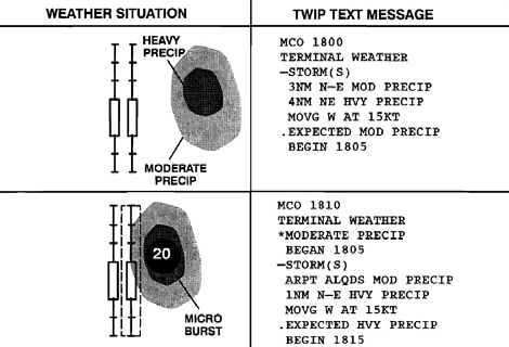 FIG 7-1-18 tion, wind shears and microbursts.
TWIP Image of Convective Weather TBL 7-1-11
at MCO International TWIP-Equipped Airports
Airport Identifier
Andrews AFB, MD KADW
Hartsfield-Jackson Atlanta Intl Airport KATL
Nashville Intl Airport KBNA
Logan Intl Airport KBOS
Baltimore/Washington Intl Airport KBWI
Hopkins Intl Airport KCLE
Charlotte/Douglas Intl Airport KCLT
Port Columbus Intl Airport KCMH
Cincinnati/Northern Kentucky Intl Airport KCVG
(b) TWIP products are generated using Dallas Love Field Airport KDAL
weather data from the TDWR or the Integrated James M. Cox Intl Airport KDAY
Terminal Weather System (ITWS) testbed. TWIP
Ronald Reagan Washington National Air- KDCA
products are generated and stored in the form of text port
and character graphic messages. Software has been
developed to allow TDWR or ITWS to format the Denver Intl Airport KDEN
data and send the TWIP products to a database Dallas-Fort Worth Intl Airport KDFW
resident at Aeronautical Radio, Inc. (ARINC). These Detroit Metro Wayne County Airport KDTW
products can then be accessed by pilots using the
Newark Liberty Intl Airport KEWR
ARINC Aircraft Communications Addressing and
Reporting System (ACARS) data link services. Fort Lauderdale-Hollywood Intl Airport KFLL
Airline dispatchers can also access this database and William P. Hobby Airport KHOU
send messages to specific aircraft whenever wind Washington Dulles Intl Airport KIAD
shear activity begins or ends at an airport.
George Bush Intercontinental Airport KIAH
(c) TWIP products include descriptions and
Wichita Mid-Continent Airport KICT
character graphics of microburst alerts, wind shear
alerts, significant precipitation, convective activity Indianapolis Intl Airport KIND
7-1-54 Meteorology
FIG 7-1-18 tion, wind shears and microbursts.
TWIP Image of Convective Weather TBL 7-1-11
at MCO International TWIP-Equipped Airports
Airport Identifier
Andrews AFB, MD KADW
Hartsfield-Jackson Atlanta Intl Airport KATL
Nashville Intl Airport KBNA
Logan Intl Airport KBOS
Baltimore/Washington Intl Airport KBWI
Hopkins Intl Airport KCLE
Charlotte/Douglas Intl Airport KCLT
Port Columbus Intl Airport KCMH
Cincinnati/Northern Kentucky Intl Airport KCVG
(b) TWIP products are generated using Dallas Love Field Airport KDAL
weather data from the TDWR or the Integrated James M. Cox Intl Airport KDAY
Terminal Weather System (ITWS) testbed. TWIP
Ronald Reagan Washington National Air- KDCA
products are generated and stored in the form of text port
and character graphic messages. Software has been
developed to allow TDWR or ITWS to format the Denver Intl Airport KDEN
data and send the TWIP products to a database Dallas-Fort Worth Intl Airport KDFW
resident at Aeronautical Radio, Inc. (ARINC). These Detroit Metro Wayne County Airport KDTW
products can then be accessed by pilots using the
Newark Liberty Intl Airport KEWR
ARINC Aircraft Communications Addressing and
Reporting System (ACARS) data link services. Fort Lauderdale-Hollywood Intl Airport KFLL
Airline dispatchers can also access this database and William P. Hobby Airport KHOU
send messages to specific aircraft whenever wind Washington Dulles Intl Airport KIAD
shear activity begins or ends at an airport.
George Bush Intercontinental Airport KIAH
(c) TWIP products include descriptions and
Wichita Mid-Continent Airport KICT
character graphics of microburst alerts, wind shear
alerts, significant precipitation, convective activity Indianapolis Intl Airport KIND
7-1-54 Meteorology