Index
565
-- Page 566 --
567
7110.65R
AIM
AIM      CHG 2                                                                                          3/15/07
                                                                                                       11/10/16
                                                                                                       12/10/15


                     FIG 9-1-12                              6. Airport Obstruction Charts (OC). The
            North Atlantic Route Charts                 OC is a 1:12,000 scale graphic depicting 14 CFR
                                                        Part 77, Objects Affecting Navigable Airspace,
                                                        surfaces, a representation of objects that penetrate
                                                        these surfaces, aircraft movement and apron areas,
                                                        navigational aids, prominent airport buildings, and a
                                                        selection of roads and other planimetric detail in the
                                                        airport vicinity. Also included are tabulations of
                                                        runway and other operational data.
                                                             7. FAA Aeronautical Chart User's Guide.
                                                        A booklet designed to be used as a teaching aid and
                                                        reference document. It describes the substantial
                                                        amount of information provided on FAA's aeronauti-
                                                        cal charts and publications. It includes explanations
                                                        and illustrations of chart terms and symbols
                                                        organized by chart type. The users guide is available
                                                        for free download at the AeroNav web site.
                                                          e. Digital Products.
     5. North Pacific Route Charts. These charts            1. The Digital Aeronautical Information CD
are designed for FAA controllers to monitor             (DAICD). The DAICD is a combination of the
transoceanic flights. They show established intercon-   NAVAID Digital Data File, the Digital Chart
tinental air routes, including reporting points with    Supplement, and the Digital Obstacle File on one
geographic positions. Composite Chart: Scale            Compact Disk. These three digital products are no
1 inch = 164nm/1:12,000,000. 48 x 41-1/2 inches.        longer sold separately. The files are updated every
Area Charts: Scale 1 inch = 95.9nm/1:7,000,000.         56 days and are available by subscription only.
52 x 40-1/2 inches. All charts shipped unfolded.
Charts revised every 56 days. (See FIG 9-1-13.)                (a) The NAVAID Digital Data File. This
                                                        file contains a current listing of NAVAIDs that are

                     FIG 9-1-13                         compatible with the National Airspace System. This
         North Pacific Oceanic Route Charts             file contains all NAVAIDs including ILS and its
                                                        components, in the U.S., Puerto Rico, and the Virgin
                                                        Islands plus bordering facilities in Canada, Mexico,
                                                        and the Atlantic and Pacific areas.
                                                               (b) The Digital Obstacle File. This file
                                                        describes all obstacles of interest to aviation users in
                                                        the U.S., with limited coverage of the Pacific,
                                                        Caribbean, Canada, and Mexico. The obstacles are
                                                        assigned unique numerical identifiers, accuracy
                                                        codes, and listed in order of ascending latitude within
                                                        each state or area.
                                                               (c) The Digital Aeronautical Chart Supple-
                                                        ment (DACS). The DACS is specifically designed
                                                        to provide digital airspace data not otherwise readily
                                                        available. The supplement includes a Change Notice
                                                        for IAPFIX.dat at the mid-point between revisions.
                                                        The Change Notice is available only by free
                                                        download from the AeroNav website.


9-1-10                                                                               Types of Charts Available
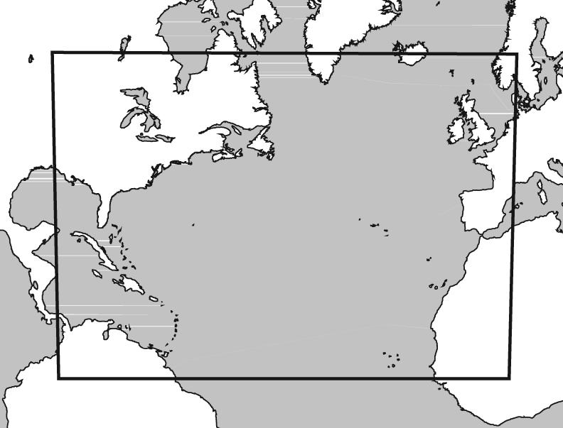 FIG 9-1-12 6. Airport Obstruction Charts (OC). The
North Atlantic Route Charts OC is a 1:12,000 scale graphic depicting 14 CFR
Part 77, Objects Affecting Navigable Airspace,
surfaces, a representation of objects that penetrate
these surfaces, aircraft movement and apron areas,
navigational aids, prominent airport buildings, and a
selection of roads and other planimetric detail in the
airport vicinity. Also included are tabulations of
runway and other operational data.
7. FAA Aeronautical Chart User's Guide.
A booklet designed to be used as a teaching aid and
reference document. It describes the substantial
amount of information provided on FAA's aeronauti-
cal charts and publications. It includes explanations
and illustrations of chart terms and symbols
organized by chart type. The users guide is available
for free download at the AeroNav web site.
e. Digital Products.
5. North Pacific Route Charts. These charts 1. The Digital Aeronautical Information CD
are designed for FAA controllers to monitor (DAICD). The DAICD is a combination of the
transoceanic flights. They show established intercon- NAVAID Digital Data File, the Digital Chart
tinental air routes, including reporting points with Supplement, and the Digital Obstacle File on one
geographic positions. Composite Chart: Scale Compact Disk. These three digital products are no
1 inch = 164nm/1:12,000,000. 48 x 41-1/2 inches. longer sold separately. The files are updated every
Area Charts: Scale 1 inch = 95.9nm/1:7,000,000. 56 days and are available by subscription only.
52 x 40-1/2 inches. All charts shipped unfolded.
Charts revised every 56 days. (See FIG 9-1-13.) (a) The NAVAID Digital Data File. This
file contains a current listing of NAVAIDs that are
FIG 9-1-12 6. Airport Obstruction Charts (OC). The
North Atlantic Route Charts OC is a 1:12,000 scale graphic depicting 14 CFR
Part 77, Objects Affecting Navigable Airspace,
surfaces, a representation of objects that penetrate
these surfaces, aircraft movement and apron areas,
navigational aids, prominent airport buildings, and a
selection of roads and other planimetric detail in the
airport vicinity. Also included are tabulations of
runway and other operational data.
7. FAA Aeronautical Chart User's Guide.
A booklet designed to be used as a teaching aid and
reference document. It describes the substantial
amount of information provided on FAA's aeronauti-
cal charts and publications. It includes explanations
and illustrations of chart terms and symbols
organized by chart type. The users guide is available
for free download at the AeroNav web site.
e. Digital Products.
5. North Pacific Route Charts. These charts 1. The Digital Aeronautical Information CD
are designed for FAA controllers to monitor (DAICD). The DAICD is a combination of the
transoceanic flights. They show established intercon- NAVAID Digital Data File, the Digital Chart
tinental air routes, including reporting points with Supplement, and the Digital Obstacle File on one
geographic positions. Composite Chart: Scale Compact Disk. These three digital products are no
1 inch = 164nm/1:12,000,000. 48 x 41-1/2 inches. longer sold separately. The files are updated every
Area Charts: Scale 1 inch = 95.9nm/1:7,000,000. 56 days and are available by subscription only.
52 x 40-1/2 inches. All charts shipped unfolded.
Charts revised every 56 days. (See FIG 9-1-13.) (a) The NAVAID Digital Data File. This
file contains a current listing of NAVAIDs that are
 FIG 9-1-13 compatible with the National Airspace System. This
North Pacific Oceanic Route Charts file contains all NAVAIDs including ILS and its
components, in the U.S., Puerto Rico, and the Virgin
Islands plus bordering facilities in Canada, Mexico,
and the Atlantic and Pacific areas.
(b) The Digital Obstacle File. This file
describes all obstacles of interest to aviation users in
the U.S., with limited coverage of the Pacific,
Caribbean, Canada, and Mexico. The obstacles are
assigned unique numerical identifiers, accuracy
codes, and listed in order of ascending latitude within
each state or area.
(c) The Digital Aeronautical Chart Supple-
ment (DACS). The DACS is specifically designed
to provide digital airspace data not otherwise readily
available. The supplement includes a Change Notice
for IAPFIX.dat at the mid-point between revisions.
The Change Notice is available only by free
download from the AeroNav website.
9-1-10 Types of Charts Available
FIG 9-1-13 compatible with the National Airspace System. This
North Pacific Oceanic Route Charts file contains all NAVAIDs including ILS and its
components, in the U.S., Puerto Rico, and the Virgin
Islands plus bordering facilities in Canada, Mexico,
and the Atlantic and Pacific areas.
(b) The Digital Obstacle File. This file
describes all obstacles of interest to aviation users in
the U.S., with limited coverage of the Pacific,
Caribbean, Canada, and Mexico. The obstacles are
assigned unique numerical identifiers, accuracy
codes, and listed in order of ascending latitude within
each state or area.
(c) The Digital Aeronautical Chart Supple-
ment (DACS). The DACS is specifically designed
to provide digital airspace data not otherwise readily
available. The supplement includes a Change Notice
for IAPFIX.dat at the mid-point between revisions.
The Change Notice is available only by free
download from the AeroNav website.
9-1-10 Types of Charts Available