Index
566
-- Page 567 --
568
11/10/16
12/10/15                                                                                                      AIM


The DACS individual data files are:                        which can be used as a basis to support GPS
                                                           navigation. Initial data elements included are: Airport
ENHIGH.DAT: High altitude airways (contermi-               and Helicopter Records, VHF and NDB Navigation
nous U.S.)                                                 aids, en route waypoints and airways. Additional data
ENLOW.DAT: Low altitude airways (conterminous              elements will be added in subsequent releases to
U.S.)                                                      include: departure procedures, standard terminal
IAPFIX.DAT: Selected instrument approach proce-            arrivals, and GPS/RNAV instrument approach
dure NAVAID and fix data.                                  procedures. The database is updated every 28 days.
MTRFIX.DAT: Military training routes data.                 The data is available by subscription only and is
ALHIGH.DAT: Alaska high altitude airways data.             distributed on CD-ROM or by ftp download.
ALLOW.DAT: Alaska low altitude airways data.
PR.DAT: Puerto Rico airways data.                               3. digital-Visual Charts (d-VC). These digi-
HAWAII.DAT: Hawaii airways data.                           tal VFR charts are geo-referenced images of FAA
BAHAMA.DAT: Bahamas routes data.                           Sectional Aeronautical, TAC, and Helicopter Route
OCEANIC.DAT: Oceanic routes data.                          charts. Additional digital data may easily be overlaid
STARS.DAT: Standard terminal arrivals data.                on the raster image using commonly available
DP.DAT: Instrument departure procedures data.              Geographic Information System software. Data such
LOPREF.DAT: Preferred low altitude IFR routes              as weather, temporary flight restrictions, obstacles, or
data.                                                      other geospatial data can be combined with d-VC
HIPREF.DAT: Preferred high altitude IFR routes             data to support a variety of needs. The file resolution
data.                                                      is 300 dots per inch and the data is 8-bit color. The
ARF.DAT: Air route radar facilities data.                  data is provided as a GeoTIFF and distributed on
ASR.DAT: Airport surveillance radar facilities data.       DVD-R media and on the AeroNav Products
                                                           website. The root mean square error of the
     2. The National Flight Database (NFD)                 transformation will not exceed two pixels.
(ARINC 424 [Ver 13 & 15]). The NFD is a basic              Digital-VC DVDs are updated every 28 days and are
digital dataset, modeled to an international standard,     available by subscription only.


                                                    FIG 9-1-14
                                   Chart Supplement U.S. Geographic Areas


Types of Charts Available                                                                                  9-1-11
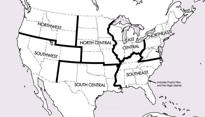 FIG 9-1-14
Chart Supplement U.S. Geographic Areas
Types of Charts Available 9-1-11
FIG 9-1-14
Chart Supplement U.S. Geographic Areas
Types of Charts Available 9-1-11